Co je Zmizelá Kutná Hora?
Projekt digitalizace a zpřístupnění mimořádného souboru historických fotografií, maleb a dalších obrazových pramenů Kutné Hory a Sedlce pro nejširší veřejnost. V rámci České republiky unikátní projekt, který má vlastní knižní edici a specializované webové stránky.
Vznikl v roce 2009 a do současnosti se jeho autorovi podařilo ze státních a soukromých sbírek soustředit bezmála dva tisíce pramenů.
Hrajte s námi
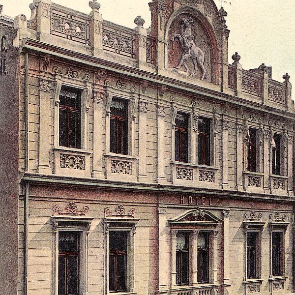
Jaký hotel zachycuje tato fotografie?
- Celkem hlasujících: 3273
- Pokud si nejste jisti, hledejte v Digitálním archivu: 25 Domy
- Správná odpověď na minulou otázku: čp. 208 Pirknerovo náměstí
Novinky
Sedmý ročník kurzu architektury
S Dačického domem připravujeme nový ročník kurzu 10 slohů architektury v Kutné Hoře pro akademický rok 2026/2027, půjde již o 7. ročník! V rámci kurzu se jeho posluchači seznamují s hodnotami architektury města a okolí. Kapacita je omezena a první lekce začíná 3. září.
Komentované procházky: prvorepubliková architektura v Kutné Hoře
Galerie středočeského kraje (GASK) realizuje v letošní turistické sezóně komentované procházky centrem města a předměstím Hlouška. Exkluzivně nahlédnete do interiérů některých objektů včetně čerstvě zrekonstruované Zelenkovy vily!